


Ruta del Jefe is a weekend of adventure cycling, education, community, and advocacy that has taken place in the Sky Islands region of southern Arizona, which we’ve previously reported on here, here, and here. Beginning in 2024, the event will occur in Cuenca los Ojos, a protected landscape in Sonora, Mexico’s Sky Islands. Below, this two-part collaborative story (“The Watershed of the Springs” by Sarah Swallow and “La Aventura” by Daniel Zaid) details what’s next for Ruta del Jefe along with other recreational and educational opportunities in these borderlands.

The Watershed of the Springs
by Sarah Swallow
On the eastern slopes of the continental divide, nestled in the borderlands, lies a volcanic landscape of corrugated canyons, valleys, and ridgelines sprawling from the northern terminus of the Sierra Madre Occidental into the Sonoran and Chihuahuan deserts. It is where jaguars, wolves, and bears roam, beavers swim, and hot and cold springs flow year-round. These are the ancestral lands of the Chiricahua Apache and Ópata (Tegüima-Eudebe-Hoba). A natural and cultural crossroads, this region is a hotbed for biodiversity, culture, migration, resistance, and sadly, one for militarization, violence, and suffering.
Many people are unaware that jaguars once existed throughout northern Mexico and the southern United States. Due to habitat loss, poaching, and human-wildlife conflict, jaguars have been completely eliminated from the U.S. They have been listed as endangered under the U.S. Endangered Species Act since 1997 and near threatened by IUCN Red List since 2002. Jaguars are the largest cat species in the Western Hemisphere, and as apex predators, they play an essential role in the ecosystem and regulate prey populations. In addition, these majestic creatures have been prominent mythological symbols of indigenous cultures of the Americas, including those of the Pueblo, Aztec, Mayan, and Incan civilizations. Historically, their natural habitat has ranged from northern Argentina to the Grand Canyon in the U.S. Southwest.

What do jaguars have to do with this story about bicycles? Jaguars are how Dani, Karla, Adam, and I came to ride our bicycles at Cuenca Los Ojos in Sonora, Mexico, the habitat of the two latest North American jaguars known to roam the borderlands.
In the fall of 2021, I went out on a limb. I asked wildlife biologist, National Geographic Explorer, and Ph.D. student Ganesh Marin if he would be willing to present his camera trap findings of these two jaguars at my event, Ruta del Jefe.
For those unfamiliar, Ruta del Jefe is an event that seeks to raise awareness of the environmental and humanitarian concerns in the borderlands through education and adventure rides. The event is named after El Jefe, a jaguar that roamed southern Arizona’s Santa Rita Mountains from 2011-2015. The long route of Ruta del Jefe circumnavigates the Santa Rita Mountains, El Jefe’s former habitat. El Jefe was believed to have been killed or migrated south to find a mate, but his spirit lived on through conservation efforts to protect the habitat for threatened and endangered species in the borderlands. During the summer of 2022, a camera trap in Sonora captured an image of legendary El Jefe, alive, healthy, and one of the oldest living jaguars. This image confirmed that El Jefe had indeed migrated south of the border, providing hope and inspiration to all fighting to protect viable habitats for jaguars in the U.S. and Mexico.


To my surprise, Ganesh agreed to present at Ruta del Jefe (RDJ) in March 2022 and purchased a bike to participate in RDJ’s 70-mile adventure ride. Ganesh also invited Rodrigo Sierra Corona, a biologist, mountain bike advocate, and member of the board of directors at Cuenca Los Ojos (CLO), and Jeremiah Leibowitz, the executive director, to participate in the event. After the festivities of RDJ wrapped up, Jeremiah and Rodrigo invited me to visit CLO in the fall to explore the potential to bring environmental recreation to CLO by hosting Ruta del Jefe there in the future and establishing cycling infrastructure throughout the preserve.

I could not think of two other people I would rather collaborate with on this project more than Karla Robles and Daniel Diaz, founders of the Sonora Gravel Social Club, Andarres.com, bikepacking extraordinaires, dear friends, and collaborators. So, we set a date to meet up at CLO during the first two weeks of October, then otherwise went on with our everyday busy lives.
Cuenca Los Ojos is a U.S. non-profit [501(c)3] that works with its Mexican counterpart, Cuenca de Los Ojos A.C. (Civil Association), to manage the restoration and protection of 120,000 acres of land historically used for farming and cattle ranching. CLO is located south of the U.S./Mexico border, east of Douglas, AZ, and Agua Prieta, MX. Its location is significant for conservation because plants and animals from several major biological zones converge here. These zones include the Chihuahuan and Sonoran deserts, the Colorado Plateau and the Rocky Mountains, and the Sierra Madre Occidental, which results in the opportunity for half of the world’s biomes to be represented in a relatively small geographic area.

Cuenca Los Ojos translates to “watershed of the springs,” named for the water present throughout the preserve. Over the past 40 years, CLO has been repurposing erosion control technologies used by indigenous peoples of northern Mexico to restore riparian areas on a watershed scale. As a result of these efforts and technologies, streams of water flow through the creeks within CLO year-round; the healthy soil retains and seeps water, has restored tall lush grasslands, prevents erosion, and holds abundant carbon. Black bear, ocelot, coati, javelina, deer, mountain lion, Gila monsters, pronghorn antelope, and at least three different kinds of rattlesnake are some of the diverse species coexisting within CLO. In addition, endangered native species, like beavers, wolves, and of course, jaguars, have been re-establishing habitats within CLO.
Jaguars are known to have territories that include several hundred square miles. So, the presence of two young jaguars just south of the newly constructed border wall could either be seen as brothers dispersing together or very well represent the harmful impact of the border wall on all mammals seeking to migrate north and south.

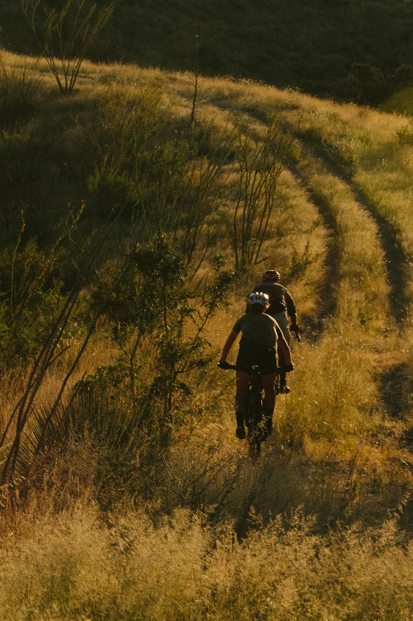
Our team spent two weeks testing all the roads and trails we could get our two wheels on at CLO. We did this to make an informed decision on whether CLO could host not only Ruta del Jefe but also basecamp day riders and bikepackers in the future. Scouting routes, particularly in places that have seen very few, if any, bicycles, is the truest sense of adventure because you have no idea what the terrain will serve you or what condition the roads are in. Completing this mission after a record-breaking monsoon season set us up for riding and hiking on roads densely overgrown with grass and cat claw, or that had been thoroughly washed away, and regularly through water up to our shins. Each scouting ride was a mystery; would the roads exist? How long would we need to hike a bike today, and how long would we be out after dark? Each day Rodrigo and CLO’s conservation director, Jose Manuel Perez, reassured me that roads could and will be easily repaired.
And, each day, I reassured my companions that our challenging efforts were valuable experiences that informed which roads and trails were suitable for public consumption and which were not. After much exploration, bush-whacking, hike-a-biking, one flat, a few tumbles, and one severe allergic reaction, we established 152 miles and six routes with a list of more mileage to explore for bikepacking connectors in the Spring of 2023. These routes are fun, technical, and challenging adventure rides that travel along double-track roads through rugged canyons filled with abundant water, cottonwood, and sycamore trees and over rolling grassland ridgelines dotted with ocotillo, cholla, and agave. There is still a lot of work to be done before this place can be responsibly and consciously open to cyclists, but our goal is to be ready by the time we host Ruta del Jefe there in March 2024.

La Aventura
by Daniel Zaid
It’s been a couple of years that Karla and I have been playing with the idea of making an event in our home state of Sonora, where we can invite the people we’ve met and those we haven’t met yet. But, honestly, sometimes I’m not sure if it would be worth it for people to come from far away to ride the roads I ride in Hermosillo; maybe it’s because I ride them all the time, maybe it’s because they really aren’t that attractive. So when Sarah invited us to join her to scout a possible venue for an event in Sonora near the border with Chihuahua, I thought this could be the opportunity to put something together.

What better company than the organizer of the Ruta del Jefe herself? While looking at the maps she sent me, I realized we’d be exploring an area I had often driven past when visiting family in Chihuahua. I knew, from previous daydreams I had while being inside the car, that this region was the beginning of the Sierra Madre Occidental, a mountain range I’ve wanted to explore since I started bike touring but haven’t been able to, mainly due to safety concerns. So this opportunity got me the most excited I had been in a long time and gave me the motivation I had been lacking to go out and ride, despite the summer heat in my city.

Before I continue, let me address the elephant in the room regarding safety concerns in this challenging area. State lines are typically common ground for conflict between rivaling cartels or factions of the same group; hence, they tend to be subject to more surveillance. Add in the fact that this is also near the border with the U.S.; there is no denying that the cartels have a presence in this region. Honestly, I finished my part of the story and didn’t even consider mentioning the cartel. After years of documenting my bike trips, I decided some time ago not to mention them in my stories because I don’t want them to glorify violence, and the situation already takes up enough space in the media. I don’t deny they exist, but I don’t talk about it unless it’s a concern. However, in this case, since we are inviting you to come here and ride with us, we want to be as open about the realities of this region as we are with the rest of our experience. But it is known among the people working in all the areas of CLO that the preserve is left alone to do what it does, and the place is safe for both residents and visitors; otherwise, they wouldn’t have invited us, and we wouldn’t be inviting you. Now, back to the story.
We borrowed my mom’s car after she made me promise I’d treat it as I treat my bike, which she only sees me washing and maintaining at home, but never actually riding. Doing as promised, I loaded her car with several days of food and took it offroad. We packed four bikes: two drop-bar gravel bikes and two plus-size bikepacking bikes, but I’ll just let you know here that the gravel bikes never left the campground.

A six-hour drive brought us to the Cuenca Los Ojos headquarters at Rancho San Bernardino, where we met with our teammates Sarah and Adam and José Manuel Perez, the conservation director of CLO. Then we all drove to Rancho Los Ojos, which would become our base camp for the next few days. This drive, short in distance but long in time, would be our very first approach to the kind of terrain we’d be facing and had me wishing for a four-wheel drive vehicle or higher clearance at least. We settled in a camp spot with a hot spring that quickly became where we could be found when we were not riding and pushing our bikes over the next few days.

Before coming here, Sarah had already presented and consulted a proposal of routes with José Manuel, so we had an idea of the roads we wanted to scout, but we didn’t know in what condition we would find them. On our first outing, we rode out of our base camp and started bushwacking immediately, trying to find a purple line among all the bushes to make the GPS match the real world. When we found the road, it was steep, rocky, and overgrown, so we pushed our bikes a couple of kilometers until we reached a saddle, where the track disappeared again among the vegetation.
We were off to a good start. Here Adam found out that his drone’s stabilizer was kaputt, which was a bummer because I was excited to be in a drone shot. We admired the layers of hills in front of us and decided, for the sake of the team’s morale, that we should go back to our camp and scout a better-looking track in the afternoon. Karla was on her freshly built Esker Hayduke, and after the first four hours of use, she had pushed it way more than she had ridden it.

After lunch, we made a second attempt, riding back on the same road we drove in, so at least this time, we knew the first kilometers would be rideable. Steep climbs and switchbacks brought us back to the gate before Highway 2, where we turned east onto a lesser-known track. In a short segment of singletrack, I got a sidewall cut on my rear tire; thankfully, I had a tube. During the process, we found out we were right in front of one of the camera traps, so we moved a bit further to get away from it, but I think Ganesh, the wildlife biologist who studies at CLO, will have some shots of three Homo Sapiens fixing a tire.

Once I was back in business, we continued through a river wash and then made it out to the Animas Valley grasslands, providing us with a panoramic of the Sierra Madre Occidental mountain range. To get to the valley, we rode on a very overgrown path full of goat head plants which made me very nervous about my now non-tubeless tire, but I made it out safely. We enjoyed a beautiful ridgeline ride at sunset, but as the sun was setting, it was clear we would still be out after dark, so Adam, who thought we would have plenty of daylight to complete a 23-mile ride and had not brought a light, sped up to make it back before he couldn’t see. Sarah and I continued and rode with our headlamps for over an hour. A very long and rough descent was going to bring us back home, but within the last kilometer, a rock threw my front wheel sideways, and I hit the ground. With a few scratches and a sore shin, we returned to our camp, where I rushed to jump into the hot springs before my body started to hurt.
In the morning, we assembled and decided to take a day off to lick our wounds and process the new information we had gathered; Sarah had developed what seemed like an allergy on her legs due to the tall grass and pollen, so she said she’d be riding in pants from now on. Only Adam went on a run to search for the GoPro he had lost the day before and scout a possible connector along the way. Our lessons from our first-day riding made it clear that we needed to adjust our expectations for daily distances due to the condition of the roads and the elevation gain and that we needed to bring our lights on every ride. During our visit, our average daily ride was 25 miles with 3,500 ft of elevation, which would take anywhere between 6-10 hours.

On the second day of riding, we were joined by Rodrigo Sierra. Rodrigo has been doing research in Cuenca Los Ojos for 30 years and knows CLO like the back of his hand (on foot). But despite being an avid cyclist, he has spent very little time biking the preserve. He told us we were about to attempt a route he’d been dreaming of riding for fifteen years, which would take us through Cajón Bonito for over 5-miles. As soon as we got on our bikes and left camp, we had to cross an arroyo, and we thought it was way too early in the ride to have wet feet, so we took our shoes off, which was a bit of an anticlimactic start. Then we climbed up the road we rode down in the dark on day one, and I recognized where I fell, but this time I rode around the rock that brought me down. We came across one of the “trincheras”, a small wall of boulders that’s an essential part of CLO’s water and soil restoration project.
Rodrigo told us there are 40,000 trincheras throughout the preserve, which sounds like a lot of work, but they are the tool used to restore the watershed, which is why so much wildlife is thriving again in this region. We were back at the ridgeline and rode among stunning cloud formations. Then a steep, rocky, overgrown descent had me wishing I had flat bars until we made it down to Cajón Bonito, a wide canyon where a river flows. We were told there’s usually some road, but the summer rains had washed it entirely out, so we rode when we could and pushed through sand, giant boulders, and water when we couldn’t. “See that?” – Rodrigo said as he pointed to debris stuck on a branch about two meters above our heads-“That’s where the water level was.” We came across a beaver’s dam, feline prints, and a pile of bear poop. After two or three hours of mostly walking, we reached an actual road and an area of the preserve called Rancho Nuevo. A CLO staff member there offered us a cup of coffee and a burrito that gave us the energy for the last push, which found us again riding and pushing in the dark.

The next day, we moved our base camp to Rancho Nuevo so that we could explore roads in a different area of the preserve. To cover two routes in one day, Karla and I went one way, and Sarah and Adam went another. Save for the first 3 km of river wash walking, our ride was the easiest we had done so far, with a very chill and progressive climb out into the grasslands and back to Rancho Nuevo via a long and rocky descent, which is clearly a theme at CLO.
After nearly a week at Cuenca Los Ojos, we moved to Rancho El Uno, a protected area managed by CLO located near the town of Janos in Chihuahua. It focuses on protecting the prairie dog and the American bison that once roamed these lands but whose numbers were severely reduced due to overhunting. We rode out to the nearest herd to see them, but the short ride came at the cost of our drivetrains due to peanut butter mud from recent monsoons that caked our bikes. The road conditions prevented us from further riding, so we spent our last couple of days together planning and dreaming about the possibilities while we lit up the grill and had a taste of sotol, the distilled beverage typical of Chihuahua.

Recently, Sarah has made public that Cuenca Los Ojos will be the place for the next edition of Ruta Del Jefe in March 2024. There’s still a lot of work to do to make it happen, but words have been spoken, hands have been shaken, and CLO has started to improve some roads, which will surely increase the riding-to-walking ratio we had. On our last ride there, we saw a bulldozer working on a road that would give access to less off-road capable vehicles. We rode and pushed through all the bad stuff so you can ride through the best stuff! Ok, there might be a little pushing still, but it’ll be a majestic push.

CLO is the kind of project that makes me hold onto the idea that there are solutions to the impact that humans have had on La Tierra (the Earth) and that not all is lost when it comes to preventing our planet from becoming the scenario for an apocalyptic movie. I admit sometimes I lean towards a feeling of despair and that it’s too late to do anything, but I try to do my part because I care and because I couldn’t live in a spaceship even if given the option since I’m claustrophobic. It has taken a lot of work for a relatively small group of people to assist in bringing back the water and the wildlife that once thrived here, and now we have the opportunity to partake in this project. Riding our bikes while doing it? You don’t have to tell me twice. Join us for RDJ, and let’s embark on a little change together.
Stay tuned for more information!
learn more about Cuenca Los Ojos.
Learn more about Ruta del Jefe.
To learn more about Daniel and Karla’s work promoting adventure cycling in Mexico, check out Andarres.