


“I’m not tired, I’m just tired of the situation.”
Words by Cjell Monē and photos by Corbin Brady
Corbin’s family calls it ‘Going Nuclear’…It’s precisely the time when ol’ Hard Corbin stops enjoying the infinite riches of bikepacking and tells the world to ‘go, fuck itself.’ Two days of bike carrying and rationing food are a good recipe for a nuclear reaction.
Cass Gilbert over at bikepacking.com teamed up with a couple of nut-jobs living on an organic farm outside of Quito, the Dammer Brothers, to ride their bikes across Ecuador. I can’t tell you a lot about these guys other than between them they have 7 million bikepacking miles and their hobbies include lifting steel fatbikes over their heads.

If you look at the comments under the routes Cass Gilbert has published in the past, it usually looks something like:
RocketRon: 6/10 my ass. Hardest thing I’ve ever done.
MotorMary: Can’t believe they call this a “route”. Rode a total of 10 feet.
Bugoutcylist69: had 2 coronaries pushing my bike…6/10 difficulty… on a dirtbike piloted by Jesus Christ
Needless to say when Cass and a couple dudes built like Stalone in Rocky IV say ” I won’t mince my words. There are sizeable sections to this ride that are nothing less than punishing; it’s the hardcore… ” young men and women should heed these warnings.
It was the carrot of “Single Track” that compelled us. The Trans Ecuador Mountain Bike Route is 764 miles of dirt roads, footpaths, horse trail and wide open paramo down the Andes from Columbia to Peru. There exists a “dirt route” option that is pretty much the same route save some incredibly difficult hike-a-bike sections.
It’s when the two routes diverge on the map, one can be sure there’s good reason why. The ‘single track’ option would head high and far away from anything that resembled a road, path or trail. It left us, on a number of occasions, asking each other if we were on a trail at all, or could see one, or if our GPSs had any clues. The reply was almost always “nope.” Lifting our loaded bikes above our heads was more than not, the easiest way forward.

The trip came together under the orchestration of Izzy Krompegel. Izzy is a former employee of Black Sheep Bikes which is a common thread for her, Corbin and myself. Our fourth was the lead engineer and all around top athlete, Jenny Carmichael of All-City Cycles. A bikepacking dream team ready for adventure in far away lands…a perfect recipe ripe for mid-level online cycling publication.
After a few snafus in Quito, namely, Jenny arriving a day after she originally estimated, and I cracking (and subsequently repairing) my frame after some foolish skate park shenanigans, we were off.
The first portion of the route circumnavigated the volcano just to the south, Cotopaxi. It was a wet and muddy few days. We were happy to hose our bikes off, make coffee in the square and check out the stinky operation of the local cheese guy in the first village we came to.

Between the herculean climbs and massive descents, we would stop in to nourish ourselves at local comedors. Set meals usually came with a soup, “sopita”, and segundas which were usually chicken drumsticks or beef beat into submission alongside a heaping portion of rice and some beans. Jenny always seemed to be the lucky one with the chicken foot hidden in her soup.
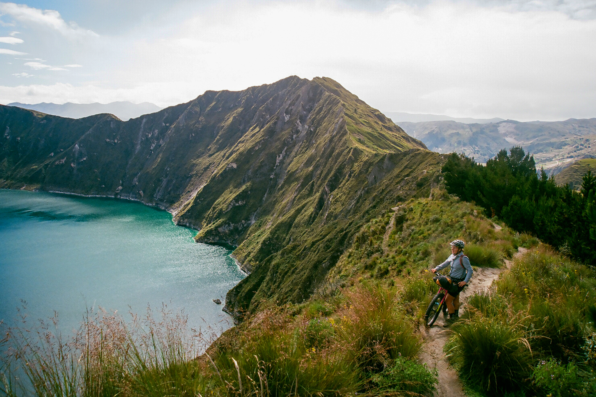
The elevation wasn’t without its reward. Vast unimpeded views were the norm and not the exception. The countryside was a patchwork of green pasture and farm fields. Breathtaking was not only the result of the unrelenting altitude but the constant and unreal scenery that was on tap.
Early on, the large numbers of dogs became a theme. Ecuador, by my measure, could use a Bob Barker to remind its citizens to get their pets spayed or neutered, because conservative estimates would have us being chased by twenty or more dogs per day. Some were street dogs and some protecting homesteads, but oddly enough, it was the working shepherd dogs who we had the least issues with.

Jenny started a photo project early on cataloging the cutest among them (still waiting on those thoughtful images @minnepoopa). Corbin and I were happy to arm ourselves with stones as a deterrent. An empty cocked hand did little to dissuade the brave and observant K9s but a few actual rocks in hand were usually all that was required. The practice of putting an aggressive dog in its place with a few rocks was the practice of elderly women, small kiddos and most everyone along the route. Our sense of ferocity of a dog sharpened over the month. Only a couple dogs a day would actually get close enough to nip and our whispering and rock dissuasion improved to the point where we were usually up to the challenge.
I would recommend a small artisanal rock holster to anyone attempting a trip. I would often keep the rocks situated in the vents of my helmet which worked until it didn’t and then we were reduced to skid whips, shouting and my personal favorite, getting Corbin between me and the dogs.
Our time as a foursome was short. Jenny and Izzy headed back to Quito and ultimately back home while it was up to Corbin and me to navigate what remained of the route down to Peru in the 3 weeks we had left.
The rainy season was hanging on into June which meant most of our days had rain involved. Many nights we utilized shepherd huts made of grass and branches, or sometimes the odd piece of lumber. The moisture tested our fire making skills…Corbin is still working on his merit badge.

He does, however, earn his photography badge on the trip. These images are all taken on his 35mm SLR, and captured on around 30 rolls of film which weighed about as much as two Rohloff hubs. He carried his “kit” in a backpack, which also served the group well by adding capacity for extra supplies when the expand-ability was needed. Thanks, Backpack-guy!
When we couldn’t hit a comedor we prepared pasta or quinoa. Izzy and Jenny’s backcountry culinary aptitude shown greatly, our meals after they left got considerably more utilitarian.
A detour to Chimbrazo was a welcome one. The vicunas (alpaca’s skinny cousins) became more numerous as we left 14000′ behind and began the climb to the rufios (base camp buildings) above. Around 50 switchbacks later we locked up our bikes and hiked up the side of the volcano to top out at 17000′ which Corbin had made a point of reaching. I congratulated him on his 16900′ accomplishment and we bound back down to the bikes. A sweet sunset single-track decent got us back to the park entrance where we laid out bedrolls and stayed quiet until we were sure all employees were gone.
A Dammer brother had recommended the decent from the 14000′ volcano base directly to the jungle below. He was nice enough to include a GPX file to guide us down. Wow-wee, a highlight of the trip for sure. Over 5000′ later we arrived at the bottom after hitting some of the steepest, muddiest, gnarliest bits we had ridden since arriving. The route after reaching the bottom must have been made by an ultralight aircraft because it was loosely based on the roads that actually existed, but that sweet decent made it worth it.

When someone at home asks about the trip it’s very difficult not to recount the most challenging of days we spent out there. A day or so north of Cuenca, there is a section where the “single track” version of the route follows a much more direct path to the south and the “dirt route” seems to circumnavigate that area. Upon further investigation, the direct “single track” version crosses a relatively high number to topo lines…leading us to believe that there was going to be some climbing in there.
We joked about it afterwards, if we were to meet ourselves in Quito, but 30 days later and all the wiser about the route, we would likely try and convince our former selves that the “single track” version was very very difficult and you’d be well served to take the ‘dirt route”. Our former selves would likely discount that advice for being weak and less adventurous. And so it goes.
As we set out on the “single track” line we climbed up in elevation along a few small farm fields and then above we passed a rudimentary irrigation reservoir. This was the last time we had the luxury of following a trail, path, or hint of any traveler before us. At the reservoir, we searched around for a trail or path but quickly realized it was now up to us to blaze our way ahead along the GPX line laid out in front of us.
The ground was saturated and skipping around to keep shoes dry finally proved futile. We covered a small portion of the 30 miles section over the next few hours. That brought us to the base of a steep ridge 500 feet above our heads. Again we zoomed in tightly on the GPS which yielded nothing. It was up to us to scramble up the steep hillside. Pushing bikes was no longer a viable method of forwarding progress. We hoisted bike above our heads and began climbing. At a point on the long scramble up the crumbling tussock covered hillside I checked my GPS again. Of the 30 miles for this section, we had probably covered 3.
I had half a thought it might be a good time to turn back as we didn’t have the provisions for 10 times the effort we had just given. I did, however, notice that the route undulated up high for some time and then dropped down along a dotted line…dotted line, like a trail…oooo, a trail, how glorious the thought.
After gaining the ridge it was more of the same. Corbin had yet to go nuclear but we weren’t talking much either. More bike carries and scramble. Long gone was the sweet time of pushing the bike along the ground. The sun was now setting, it was time to camp.
We found a saddle that had a trickle of water. We were glad to be wet camping. I should also mention that since climbing and gaining the ridge the scenery had become intensely beautiful. Grand views of vast, sheer-walled valleys framed Ecuador’s tallest volcano, our old friend Chimborazo.
After setting up our tarp and playing our new favorite card game, cribbage, we were treated with an amazing scene of a husband and wife team of Caballeros riding along the rugged Páramo . Their silhouettes were highlighted by a spectacular sunset. They rode up with three shepherd dogs. They were as likely as interested as to what we were doing, as we were interested in what they were doing, a long ways from nowhere. It had been a day since the last human encounter, we were in a very remote part of the country.
The next morning we took stock in what remained for food. By this time we had covered around 5 of the 30 miles. 5. I was getting hungry thinking about it.

I knew we were shooting for the dotted line and things had to improve when we got there. We were treated to a section of very rough but slightly undulating section of thick grass were we able push bikes again….ahhh, pushing. The route again went directly up a few ridges where pushing was no longer viable. scramble scramble scramble with loaded rigs on our backs. Saw one other cowboy and that was it for human sightings. We were out there. After a break and a small number of slightly foul pumpkin seeds from weeks before, we again hoisted our bikes. Corbin started asking about the whereabouts of this “dotted line” although I noticed he wasn’t asking in a kind and friendly way. I could sense that nuclear meltdown was imminent.
I can’t tell you the number of times that I checked progress and was stunned. Now around 10 of 30 miles had been covers. Remote, stunning and fucking hard. A few most scrambles that had us slipping and falling down some steep sections made the whole scene almost poetically futile. 12 of 30 miles. There was a point were a game trail appeared on a ridge and I filmed Corbin riding, RIDING, his bike. It was as short as it was glorious. Corbin again inquired about this dotted line, but by this time the nuclear sequence had commenced. He’d had it. What was the point of all this bike carrying? And where the hell is this dotted line!
“I’m not tired, I’m just tired of this situation.” Pretty much a lie, because this had to be the most tiring of bike “rides” either of us had ever attempted.

We had another meager snack at a saddle with a lake and the start of a dotted line. Oh sweet sweet dotted line. The dotted line turned out to be a rotten trick. For all the elevation we had gained, the dotted line was more bike carrying up steep unrideable, un-pushable terrain. After a few more hours of that, we seemed to be at a high point.
Down. Down down down. We had another short-lived section were I filmed Corbin as he skidded and wheelied his way down. The faint horse track soon got steeper and rockier and all of the sudden the trail deteriorated further until the thought of riding was only a memory.
The trail/path, whatever it was became very hard to walk down with the bike on the back. Steep eroded walls caught handlebars and sent you spinning down a steep boulder-filled stream bed. This was the height of the nuclear reaction. Curse words that I dare not repeat of the Radavist poured out of Corbin’s mouth. This descent wasn’t a descent at all but a struggle for survival.
The flat meadow at the bottom was no reprieve. It was a lowland that had muddy cuts in the valley wall. Again, un-pushable and ever-punishing. Afternoon turned to evening and all of 20 miles had been covered in the 2 days.
We started looking for outs, but rivers and steep valley walls stood between us and faint roads. We pressed on along the GPX track. The last 10 miles were some of the chunkiest sloppiest riding I’ve done in some time….but we were riding. It felt great. Spirits had lifted since the ridge of doom, followed by the scramble of death, followed by the descent of sadness and the swampy valley of solace. We were riding and loving it. The last 5 miles were a road, glorious potholed, dog infested road. The sunset as we check ourselves into a small guesthouse. The pictures are amazing and the account is one that will be called upon whenever I remember back to this trip. 30 of the toughest miles I’ve ever traversed accompanied by a bike.

Cuenca was a welcome respite. We Air BnB’ed and did laundry and road our unloaded bike around the city. We even caught the tail end of a downhill race. Cobbles, old churches, and good coffee. Loved us some Cuenca.
The route south was beautiful and wet and tough. The time spent above 10000′ has a way of breaking you down. When we wrapped up in Loja, another beautiful Ecuadorian City we were pooped. Proud of our accomplishment and happy to be done. A few days on the beach and some well deserved down time back in Quito before we boarded our planes and returned home. The TEMBR Route is no joke. I have no advice for anyone attempting it, other than you should bring a small rock pouch and a couple friends.
____
Follow Cjell on Instagram and follow Corbin on Instagram.
